
The continuing adventures of the Shivers family......
They say La Nina guarantees a dry and warm spring in the desert southwest. A strong La Nina was in progress during the Winter of 1999. Gas prices were at an all time low. Air fares were also about as low as they get. The time was right for a Spring break trip to Arizona and the canyon country of southern Utah. Just after Christmas, I made reservations and lined up a motorhome rental. Anticipation ran high while the days slowly passed. I spent much of my free time researching attractions and planning a tour route. Finally, we landed in Phoenix. Now, for the rest of the story....
The motorhome worked out great. It took me a couple days to relax, because I thought the transmission sounded a bit noisy. Due to the fact that we were often as far away from mechanical help as you could get, even by Alaskan standards, I couldn't help but worry about what if? By the fourth day, I was convinced it was fine. The space the motorhome provided gave the kids plenty of room to be kids and not drive us nuts.
On our first day, we hit the road out of Phoenix in the mid-afternoon, heading south towards threatening skies. It wasn't too long until we found ourselves in the midst of a genuine desert dust storm, followed by a genuine desert cloud-burst near Picacho Peak (LINK). By the time we reached Tucson, the skies were rapidly clearing.
We needed groceries, so I left the freeway on one of the few city streets (Speedway) that sounded familiar to me (Its been more than 25 years since I was a school kid in Phoenix). It passed straight through the University of Arizona and on into suburbia with no sign of a store larger than 7-11. After some 10 miles or so, we finally (we being the adult female of the party) asked directions to the nearest store. It was only one major street to the north. On the way back to the freeway on that road, we passed 3 more large stores!
Continuing south on the freeway, we shortly came to the exit for Tucson Mountain Park, where I hoped to find a vacant camp site (I was worried about that too - it was a Friday night in the heart of snowbird country). Of course, there was a large grocery store at the exit!
The Santa Catalina Mountains were bathed in a gorgeous red glow as we pulled into the campground ( Map). It was probably only three quarters full and was a very nice place, full of a variety of cactus, to the delight of Linda and the kids. A site with electric hookup was only $10.00, and the sites were nicely spaced. We crashed hard, after a long day of planes, airports, elusive stores, and tumbling tumbleweeds.
Thanks to the time change, we were up easily before 7 AM and arrived at the Arizona-Sonora Desert Museum (LINK || Map) shortly after the 8 AM opening. Its a zoo (Mexican Wolf || Bighorn Sheep || Prairie Dogs) and arboretum (Hedgehog bloom || Century Plant bloom || Cactus Nest || Occatillo bloom) with two miles of trails through natural settings. We had a great time there, and were back on the freeway heading south by 11 AM.
We stopped to visit the beautiful San Xavier del Bac Mission (Map) and enjoyed a lunch of fry bread cooked to order by the local Papago tribe. We also visited the older and for a time abandoned Tumacacori Mission (inside || Map), which is now a National Monument (LINK).
Next, we ventured on foot across the border, into the rat race known as Nogales, Sonora. It was good for the kids to see how good they have it. The poor of Nogales leave a much more lasting impression than the few homeless folks they have seen in Washington, DC. In less than two hours, everyone had a souvenir to their liking, and we walked, unquestioned at the border, back into Arizona. Some 20 miles northeast of Nogales, we did pass through a U.S. Border Patrol road block, but were waved on through without even coming to a complete stop.
I've never been much at dickering, but I thought I did pretty well there, getting most items for about half the original asking price. I even tried out my rusty Spanish. This was probably great entertainment to the indigenous merchants, but I remembered enough to know that I wasn't insulted (at least not before I was out of ear-shot).
The plan called for camping at a Forest Service site called Cochise Stronghold, but the dirt road to it from Tombstone (LINK) was far too washboarded to tolerate for 25 miles. The motorhome didn't rattle much on paved roads, but a ten mile run on a rough dirt road in Saguaro National Monument (LINK) near the Desert Museum proved deafening, with the front suspension feeling like it was about to fall completely off! We ended up at a hilltop pull off, just a mile out of Tombstone (Map). The view stretched for miles in all directions, and was wonderful as long as you didn't look down. Trash and broken glass covered the ground - everything from mattresses to pogo sticks, plus golf bags and recliner chairs littered the top of that hill. It mattered little. Dinner and bed were all that was on the agenda.
On the highway at sun up, day three was to be a cruising day. We headed north under sunny skies. Several hours later, I noticed a sign at a dirt road turnoff that stated " Rockhounding Area (LINK || Map), 2 miles". We followed the track out into the desert. It was narrow and rocky, but without those god-awful washboards. The rocks to be found turned out to be fire agates - perfect material to try out in the rock tumbler I got for Christmas. We all gathered the little agates for about an hour, then returned to our northward course.
Clifton, Arizona sets in the bottom of a narrow winding canyon. Its main street was lined with empty buildings and barely provided room for two cars to pass. Up on the side of the canyon, the company town of Morenci, still looked lively as it sat next to a massive open pit mine. The road continued to wind and climb to a viewpoint above the pit. There we were surprised to be met by a lone bighorn sheep, which seemed to be trapped on the pit side of the 8 foot chain-link fence! It worked its way back and forth, and somehow finally got out and crossed the road on its way back to a more normal environment.
The road, known as the Coronado Trail, climbed on northward, winding higher and higher toward the White Mountains. The nature trail at 9100 feet on the Mogollon Rim (Map) followed a ridge crest through forest that would be more common in places like Oregon. It was a nice walk, except for the aroma of a nearby skunk, and a welcome break after several hours of curves and cliffs.
Hannagan Meadow (Map ) was still partly snow covered, with fresh snow visible on top of the meager winter snowpack. It must have dumped here during our desert cloud burst. At the town of Alpine, we filled up the propane tank as insurance for the coming chilly night. Being only 5 miles from the New Mexico border, I honored a request from Joanna to make a 15 minutes side trip so she could add another state to her "been there" list.
At the pass just north of Alpine, the cargo hatch of the motorhome was stuffed full of firewood, in anticipation of warm campfires to come. Springerville offered a nice Safeway to resupply munchies and staples. Camp that night was at Lyman Lake State Park (LINK || Map), another $10.00 site with both water and electric.
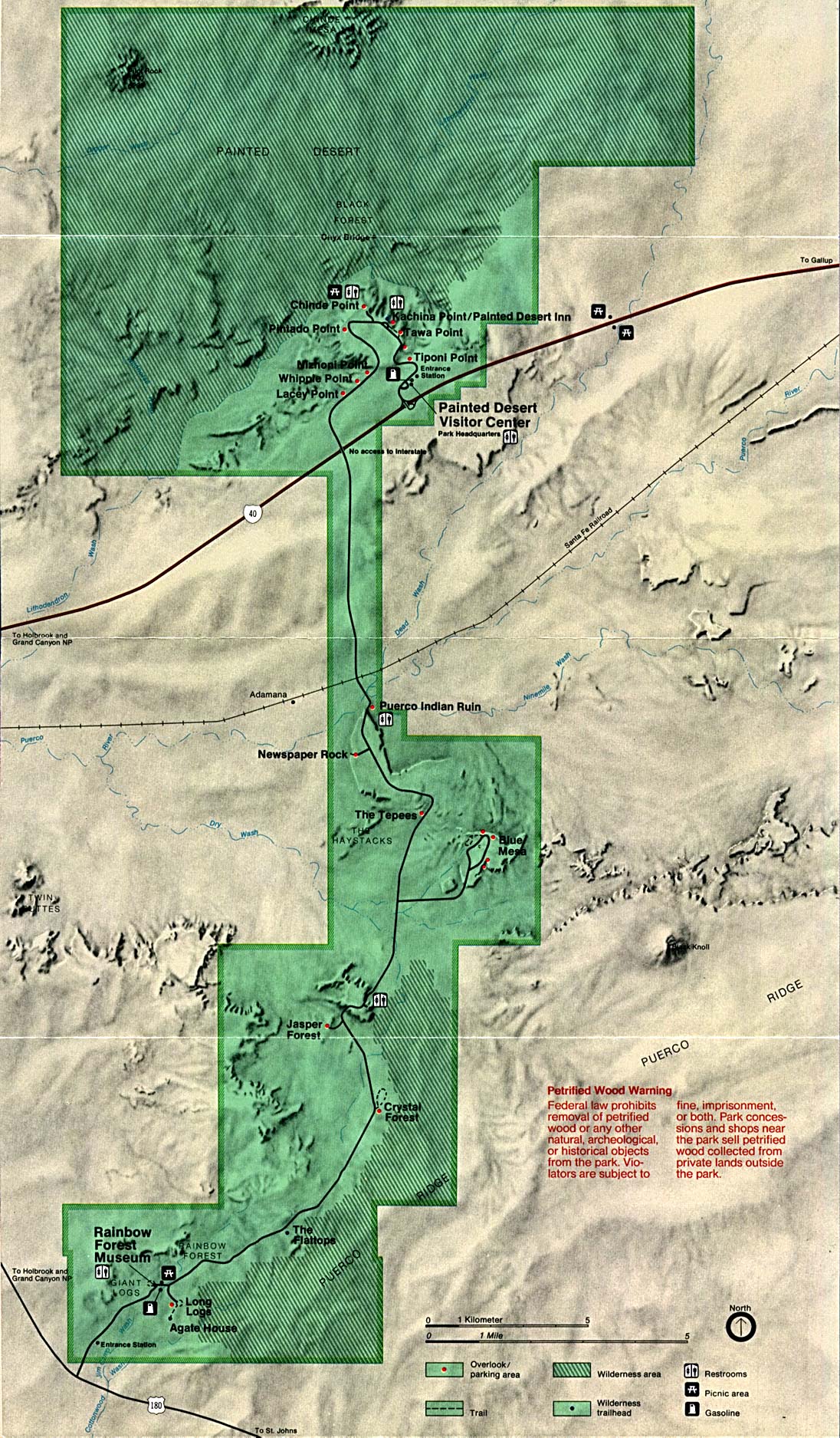
By 9 AM, we were almost to Petrified Forest National Park (LINK || Park Map), when I spotted the road I had found on maps that looked like a good place to legally look for some specimens. It turned out to be the old highway, and after closing a gate, we followed it north on pavement that was nearly covered with vegetation. It ended at a fence that marked the park boundary. We backtracked a ways to be sure we were on public property (as shown on a land status map) and got out to look for wood. We didn't find much, but did get a few very small pieces that will also probably end up in the tumbler. Matt found a small pottery shard, and was disappointed when informed it was illegal to keep.
In the park, several short walks provided a good introduction to its wonders. A short nature trail leaves from the south visitor center and passes through an area full of petrified wood, including one massive intact log. Another half mile trail visits an ancient ruin made of chunks of wood. Its well named the Agate House. Nearby, Newspaper Rock is covered with graffiti from those early residents. We lunched at a viewpoint overlooking the badlands called the Painted Desert.
Continuing north, the next stop was at the National Historic Landmark called the Hubbell Trading Post (LINK), where Linda's wish to see a Navajo weaver in action came true. In another hour, we stood at the brink of Canyon de Chelly (LINK), looking down on the cliff dwelling known as White House Ruin. A mile and a half later, we stood at the ruin, looking back up at ant sized humans some 600 feet above at the parking lot viewpoint. We all agreed that the trail was considerably less steep and easier to walk than the road up Bull Run Mountain to our house. It was a very scenic trail that passed through two tunnels as it switchbacked down to the canyon floor.
Sunset and moon rise were enjoyed from the Spider Rock (Map) overlook, 1000 feet above the base of the 800 foot pinnacle. Shortly thereafter, steaks were sizzling on the little above ground grill in Cottonwood campground (Map). Canyon de Chelly is at the southern edge of the sandstone slickrock country that covers much of the Colorado Plateau in southern Utah. The next day we drove north through a land of sandstone with scattered volcanic necks like Church Rock (Map). We passed close to Agathla Peak (Map) before arriving at the sandy dirt loop road through Monument Valley of movie fame.
From there, the scenery just got better. Near Mexican Hat, an overlook of the Goosenecks (LINK || Map) of the San Juan River views a winding 1000 foot gorge where the river flows 10 miles to make 1 mile of progress toward the Colorado. Signs at the Gooseneck's turnoff warned of "5 MPH Switchbacks", "3 miles of rough gravel road", and "not recommended for Motorhomes and vehicles pulling trailers" ahead on the main highway. Not recommended didn't mean prohibited, so on we went. The stretch in question proved far less challenging than advertised. The smoothly graded road (I suppose it may have been recently graded and could often be worse.) climbed up a 1000 escarpment at a tolerable angle, with only a couple short sections where meeting the rare oncoming traffic could have been hairy. We stopped several times while climbing this "Moki Dugway" to take pictures and enjoy the views.
By this time, the NOAA weather radio was beginning to broadcast a rather disturbing forecast of pending high winds and perhaps snowfall. I determined to make it all the way north to Goblin Valley that day, in order to hike the Little Wild Horse slot canyon the next morning before the weather deteriorated. A slot canyon hike was my number one priority for this trip. Although I had a number of possible slots included in the planned itinerary, wet weather would make all of them out of reach for the motorhome due to the slick and perhaps bottomless mud that would form on their dirt access roads.
We sped northward on past Natural Bridges National Monument (LINK || Map), not taking the time to drive its fairly short loop road. The wind was becoming noticeably stronger as we neared the northern end of Lake Powell. It was covered with white caps, but the sun still shimmered on its surface. The highway followed a narrow canyon north from the lake that provided some shelter from the wind. I decided I was rushing too much, and stopped at Hog Springs rest area for a break and to give the kids a chance to play in a stream before the colder weather moved in. We all waded up and down the stream, enjoying the warm sun and the sun warmed shallow clear water. At several places, ice cold springs welled up from the stream bed or trickled in from cracks in the sandstone.
As the road climbed out of the canyon, the terrain changed to a wide open plain with the snow capped Henry Mountains barely visible to the west through a haze of blowing dust. Crosswinds occasionally jolted the motorhome, but for the most part the wind pushed from behind, noticeably slowing the drop of the gas gage as the miles ticked off. At Hanksville, the propane and gas were topped off, and a few snacks were purchased at a store uniquely located in a cave that formed three of its walls as well as the roof.
The kids had been asking every day to play on a sand dune, and just north of Hanksville, a bright red dune right next to the road looked like the perfect place to grant their wish. In the wind howling, our tracks disappeared just about as fast as we made them. A short time later, the turnoff to Goblin Valley ( LINK || Map) led toward the sandstone ramparts of the San Rafael Reef. I proposed for us to proceed directly to the trailhead for Little Wild Horse and camp near there, where we would have the desert setting to ourselves, save a few bucks on the camping fee, and ensure an early start for the hike up the slot. Unfortunately, I thought I knew the way, and didn't consult the map. At a signed turn for Goblin Valley, I continued straight ahead on the paved road that quickly entered a deep gash trough the reef and turned to dirt. I must have driven 10 bumpy miles past the reef before I was sure that we had passed Little Wild Horse.
By the time we got back to the notch through the reef, the sun was setting and the full moon was rising. We found a nice place to park for the night, and the kids and I set out to explore while poor mom stayed behind to cook dinner. The sandstone cliffs of the reef looked like a honeycomb, pot marked with small caves and hollows. The kids felt a need too explore each one. We climbed about a third of the way up the wall before the exposure and angle turned us back. It was getting too dark for rock play, and Linda and the microwave had dinner ready in no time. After dinner, we all walked down the wash through the gap, looking futilely for the entrance to the slot. Back at the motorhome, I finally looked at the map and discovered we were miles north of the slot. I'd followed the wrong road!
Then things got worse. Joanna came down with a case of the flu overnight. Her upset stomach had us up a number of times during the night. Fortunately, she had only a very minor fever, so we were not too concerned about the vast distance to the nearest hospital.
The next morning, high clouds dimmed the sun, and the wind was still unfriendly. The map led us quickly to the trailhead. Joanna, though very sick, demanded to try to hike. The five of us started up the wash at just after 8 AM. Everything I had read about Little Wild Horse Slot Canyon said to expect some pools of water in the canyon, but since the winter had been so dry in the southwest, I thought we might luck out. There was supposed to be a large pool with a dry falls just a short distance up stream from the parking lot. It was said to be the most difficult obstacle on the entire hike, both because of the depth of water as well as the climb up the falls. When we found the large hole to be dry, I knew water would no longer be a problem. We all climbed the falls, just for fun, as there was an obvious route around on the left wall of the canyon.
A short distance further, the Little Wild Horse Canyon branched off to the right, while Bell Canyon continued straight ahead. Its possible to hike a loop through both canyons, but with weather questions and a sick kid, that was not an option. Little Wild Horse was supposed to have much better narrows, and we soon found out that it would not be a disappointment. The walls closed in quickly, and in several places my pack got caught as I turned sideways in order to pass constrictions. In a few places, the sand floor was replaced by a "V" notch of sandstone. Other areas had a wider, swirling sandstone floor. There were a couple of chalk stones jammed in the slot that required a crawl through the tunnel they created. Hundreds of feet above, the narrow slit of sky began to show a few patches of blue.
Joanna was a real trooper, but she began to lay down whenever we paused, which started to worry me. I convinced her that she had seen the best the slot would offer, and Linda volunteered to take her back to the motorhome. The twins and I pushed on. Occasionally, the canyon would widen out, then pinch back in. When it opened up for about a half of a mile, it appeared we were nearly through the reef. Then it narrowed down once again, with much shorter walls, but enormous over hangs on each side, giving it a subway tunnel like shape. There was a tight squeeze (at least for me) through a tunnel under a boulder, and another dry falls where I had to help the twins up. This narrow section was fairly short, and when we emerged, I was pretty sure we were through the reef.
It was going on two hours since we started the hike, and I felt it was time to head back. Much of the return seemed like new scenery, since the views were reversed. The sun was out most of the time, and occasionally filtered all the way to the slot floor. I'd already shot most of my film, so I tried to control myself and conserve, but couldn't, and soon was out. The wind had been at our backs on the hike in, and now was gusting surprisingly hard into our faces. As the canyon twisted, we would go through calm sections, then make turns that brought us face first into gusts I would guess were nearly 50 mph, even there at the bottom of a 300 foot deep, three foot wide crevice! Sand blasted our faces, and we had to walk looking down and occasionally had to stop completely and cover our eyes for protection. The twins didn't complain at all, even though at times it was quite unpleasant. With far fewer stops for photos and gawking, we made the trip out in about an hour.
We met two parties below the Bell Canyon junction, both of whom returned to their vehicles shortly thereafter due to the nasty wind. Linda and Joanna had made it back safely, much to my relief. I was able to truthfully tell them that they had seen the best that the slot had to offer.
I had read that nice selenite crystals could be found along the road just east of Little Wild Horse. The sky was mostly clear, and the crystals were easy to find as they reflected sunlight like broken glass. I gathered quite a few in about 10 minutes, and Linda joined me in the gale to enjoy the easy pickings. The kids were tired and intimidated by the wind driven sand and stayed inside. Kayla was about to brave the outdoors when we returned, and she was a good sport when we declined to make another excursion. It took every bit of my strength to shut the side door on the motorhome in that hellish maelstrom. Just a short distance further down the road, a much larger glint forced me to stop to investigate its source. It turned out to be by far the largest crystal found, with at least a dozen others worth collecting in the immediate area. Several were more than 6 inches long and over an inch thick. They appeared to be much clearer, with fewer sandy inclusions.
The sand storm continued to increase in intensity. The road crossed a wide flat for the last mile to so back to the Goblin Valley Road. It was a quite sandy stretch on the way in, and now all that sand was in motion. I felt it was necessary to keep the speed up to avoid becoming stuck in drifts of sand that had piled up to more than a foot in many places across the road. Visibility was extremely poor, and several times I yelled for Linda's opinion on where the road was! Joanna, who was laying on the bed in the back of the motorhome, said she enjoyed the ride immensely, that she had been bouncing airborne as we hit those sand drifts at ramming speed! Obviously, her stomach was feeling better. We did make it back to the Goblin Valley road in one piece, and although it was also unpaved, it had a much wider packed/graded surface.
A visit to Goblin Valley itself was out of the question. No one wanted to get out again, and the scenery would have been invisible anyway. Heading back to Hanksville, the wind rocked the motorhome with unending violence. Sand and dust filled the air, blocking everything from view, including sometimes the road. Fortunately, the motorhome did not seem to let much dust leak in! Turning west toward Capital Reef National Park (LINK || Park Map), our route entered a somewhat more wind sheltered valley. The wind was still strong, but no longer scary.
Just inside the east entrance to the park, we stopped and got out to view some petroglyphs. One of them looked like a bunny in a magician's hat! It was after 1 PM, yet the temperature must have been 30 degrees colder than a few hours before. The fruit trees in the park were just starting to bloom, and I assume it got cold enough there later that night to do some severe damage to the crop. We used the dump station, filled up on water, and ate lunch at the nice green campground (Map) near the park headquarters and across the road from a corral. Clouds now filled the sky, along with the dust. I fought the urge to flee to Interstate 15. We drove the park's "scenic drive" that follows the edge of the reef past the entrance to Grand Wash to where the pavement ends. Back at the main highway, we took another one mile side trip on a very rough and washboarded road to an overlook of Sulphur Creek's goosenecks (Map). Joanna was feeling better, and she braved the wind with Linda and I to walk 600 yards to the view point. I started to jog along the edge of the gorge to another promontory that offered a view both east and west, but as I crested a rise, the wind became far too strong to proceed.
Soon it was decision time. I very much wanted to follow the scenic byway, highway 12, south through Escalante and Bryce Canyon National Park. The conservative thing to do would have been to continue northwest, taking the shortest and lowest elevation route to the freeway. I'd heard so much about the spectacular slickrock country along highway 12 that I couldn't resist. The 9200 foot pass that concerned me most was less than half an hour to the south, and after that, I thought we could hole up somewhere if the weather really got bad.
The drive up over the eastern shoulder of the Boulder Mountains was very enjoyable. The west wind was blocked by the mountain mass. The subalpine meadows (Map) and barren stands of aspen were quite a contrast to the distant (but hazy) views of the slickrock country. The few snow flurries we passed through were more of a curiosity than a threat, but there was a much heavier winter snow pack left in the Boulder Mountains than there was in Arizona's White Mountains.
In no time we were back down on the open slickrock. The road descended for some distance toward Calf Creek along a narrow winding rock crest (Map) that drops off on both sides for many hundreds of feet. The wind there was perhaps the strongest we encountered. Since most of the ground for miles around was solid slickrock, there was only a little blowing dust, so the views were only slightly diminished by haze.
The high, unobstructed location also provided for the first, albeit marginal, weather radio broadcast reception we had received in more than 24 hours. A winter storm warning was in effect, with heavy accumulations expected, even in the lowest elevations. Winds had been reported in many areas at over 75 mph, with a couple reports over 90! A section of Interstate 40 between Flagstaff and Winslow had been closed due to poor visibility and the fact that several high profile vehicles had been blown over. We were in a high profile rig on a high profile ridge. It was time to head for safer environs. The nice BLM campground (Map) along Calf Creek would have to wait for another day.
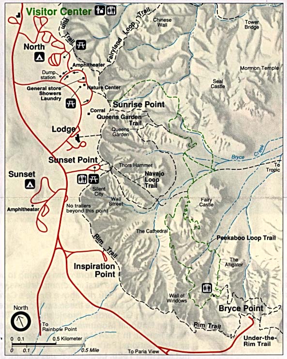
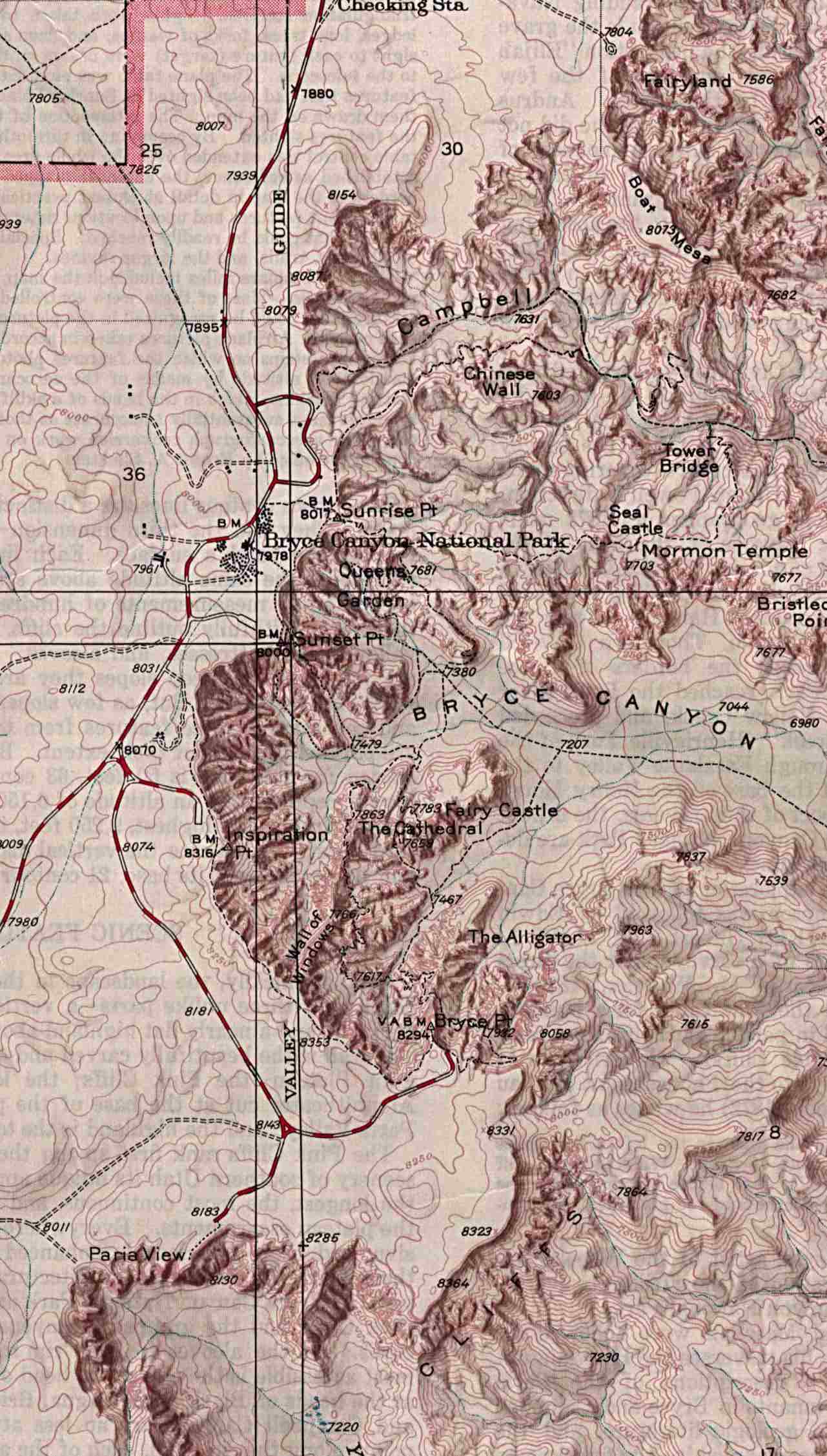
By dusk, we were nearing the east side of Bryce Canyon (LINK || Park Map || Trail Map || Shaded Relief map). I'd seen (sort of) Bryce once before, years ago in a blizzard. Light snow was falling by the time we reached the turn off for the park road, and spending the night in the park's 8000 foot high campground didn't seem too wise. The road then descended Red Canyon, which does provide some "Bryce" like scenery on a much smaller scale. We sped on into Panguitch, and bought our first restaurant made meal of the trip at that culinary Mecca known as Arby's. By the time we headed north out of town, it was pitch dark and the snow was coming at a much more serious clip.
From Panguitch, it was only 30 miles to cut over to Interstate 15. I was hoping to get to the freeway to spend the night, assuming that it would see the most snow removal efforts should the storm deposit feet of snow. 10 miles north of town, we turned west on highway 20, which offered a relatively low 7900 foot pass over the mountains to the freeway. The next crossings both north and south had passes in excess of 10,000 feet. Immediately after I made the turn, a minivan roared past me, looking to be in a hurry. The mile markers along the road started at 20, and provided a count down to 0 at the Interstate. By mile marker 15, the snow had really picked up intensity, and the road turned completely white. By mile marker 14, I caught up to the minivan. He had slowed to less than 10 mph, turned on his flashers, and although the grade didn't seem too steep, seemed to be having traction trouble. The motorhome was doing fine, but I was very worried this car in front of us would stop, and then that none of the 3 or 4 cars now behind it would be able to get going again.
The oncoming traffic eastbound had disappeared for quite some time. Could the road be blocked ahead? Every time I would get to the point of concluding that, a car or truck would finally pass.
Meanwhile, this minivan would frequently almost come to a complete stop, but then manage to speed back up. Linda kept saying "oh, my god" over and over. After a day of roads with cliffs all around, she couldn't help but imagine that somewhere just off the shoulder in the darkness lurked a bottomless abyss. By mile marker 12, the snow was coming horizontally in a cross wind, which actually seemed to help visibility by reducing the Star Trek warp effect of flakes flying directly into our headlights. Mile 10 passed, and still we climbed. Finally, that welcome 8% downgrade sign signaled we had crossed the summit. I wondered how well the motorhome would hold the road going down hill. It wasn't long before I concluded we had it made. Heck, even the minivan was flying along at 15 mph. The cars behind soon passed, but Linda warned me of dire consequences should I try to pass. Eventually the road leveled out, the snow intensity declined, and I even I was given permission to pass.
We pulled off the road about half a mile short of the freeway to spend the night. At first, it looked like it would be a poor place to sleep. It seemed like every vehicle that came off of the freeway to head east was a 4x4 that stopped there to get out and lock their hubs, but by 10 PM the traffic was virtually non-existent.
We woke up cold very early the next morning. All battery power was dead in the motorhome, and the furnace had therefore ceased operation. The engine battery was fine, and I fired it up and got out to see if I could figure out why we ran out of juice after our longest driving day of the trip. I followed the wires, and when I found the battery isolator, I gave it a wack with my fist. It sounded to me like the engine drew down, as though the charge circuit had been restored. Checking my thermometer, I found it was 7 degrees! The sky was clear, but the sun was still well below the horizon. There was only about 2 inches of snow. I wondered how much more fell back up on the pass.
Even with such a small snow accumulation, the freeway was still snow packed and icy. Shortly after getting underway, a semi passed and cut back in front of the motorhome far less than 25 feet in front, showering the windshield with rocks and gunk. No damage was done, and I fought off road rage and the urge to give chase. The snow was gone well before St. George. We stopped at a campground just off the freeway in the Virgin River Canyon (LINK || Map) to eat breakfast and take showers (the battery was recharged by then). The hillsides there were decorated with enormous Joshua Trees.
We arrived at Mesquite, Nevada by 9 AM. We were not expected to arrive at my parents new snowbird retreat there until the following evening. My poor mother was barely awake when she answered the door. We didn't realize that we had lost another hour crossing into Nevada. It was actually only 8 AM. The day was spent relaxing, visiting, doing laundry, and cleaning the filthy motorhome both inside and out. I sorted our collected rocks, depositing a pile of leaverites and packing the good stuff for the trip home. Some of the selenite crystals cleaned up very nicely.
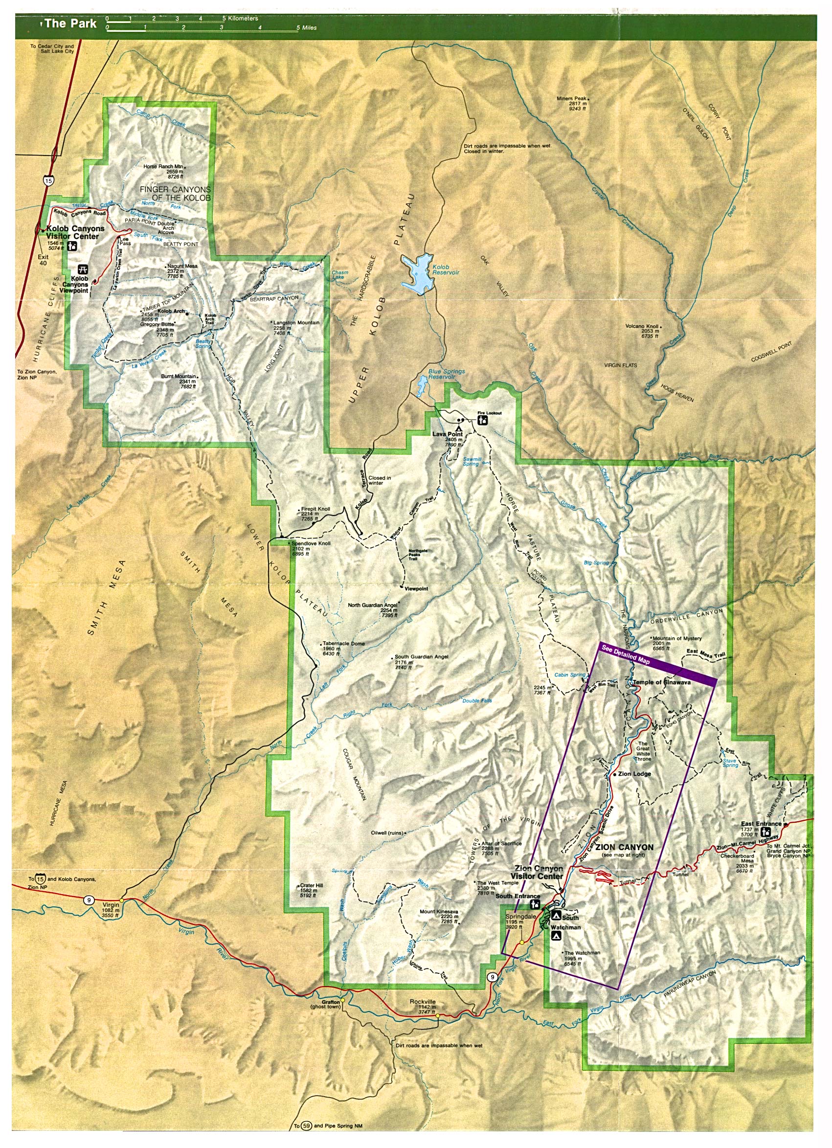
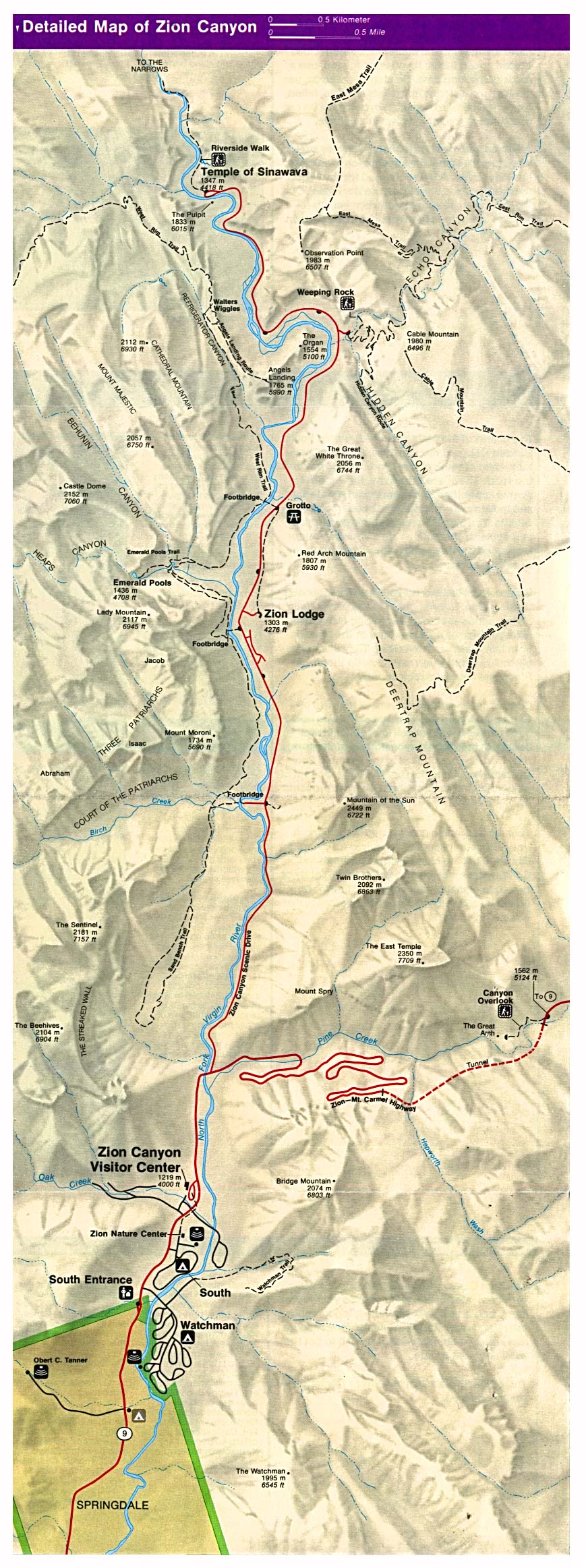
The next morning, after dying Easter eggs, we got a fairly early start heading back up the Virgin River towards St. George. My parents followed in their car as far as Zion National Park (LINK || Park Map || Canyon Map). We all took a leisurely walk up to the Emerald Pools, and then enjoyed lunch together before going our separate ways. In order to continue east on highway 9, a $10 fee had to be payed to allow the motorhome to pass through the spectacular tunnel (Map) that leaves Zion Canyon. Traffic was stopped during our passage through the 75 year old tunnel, to allow our oversized vehicle to straddle the center line and avoid the low clearance along the curved ceiling's sides. It was definitely worth the expense to avoid a long backtrack, as well as to enjoy the drive through, which passes a number of "windows" (from the outside) with views to the outside canyon world. A short distance beyond the tunnel, the road passes Checkerboard Mesa, a well known landmark.
It was mid-afternoon when we stopped to check out a sort of tourist trap just outside of Kanab. The Moqui Cave (Link) had a reasonable entrance fee and made for a nice break. The cave was once used as a dance hall and bar, but now has a nice collection of geological and anthropological curiosities, including a huge collection of fluorescent minerals.
We spent quite a bit of time there, and when we left, I was kicking myself for the delay. It had dawned on me that the Buckskin Gulch slot canyon was within striking distance. The 8 mile dirt road to the Wire Pass trailhead was rough in a few spots, but the big problems were the several wash crossings that consisted of steep and narrow dips in the road. The rear end of the motorhome dragged quite a bit when crossing these dips. After crossing one of them that was particularly abrupt, I became concerned because the angle required on the return crossing looked to be worse. Fortunately, the road surface at these crossings was soft dirt, not rock.
We arrive at the trailhead at 5:25 PM, and I set a 6 PM turnaround time to ensure a return over those dips in the road before dark. Another concern was the very black clouds hanging low to the east, but the weather radio stated that showers in the area should be quickly diminishing that evening.
I'd left my notebook that contained the trail description with my parents, but I thought I remembered that the first narrows in Wire Pass were about half a mile in. They turned out to be closer to a mile in, and our time was growing very short when we arrived. The narrows proved to be very nice indeed, with a darker more red-orange hue than those of Little Wild Horse Canyon. There were a couple of short vertical drops, but for the most part the walking was easy on smooth sand. Joanna was very glad to be in a slot canyon sans the flu!
When the narrows opened up again, I decided it was time to head back. If I'd had the trail guide, I would have known to take a bit longer and continue through the second set of narrows, which were only a short distance further. Where the second narrows meets Buckskin Gulch, some petroglyphs can be seen. Oh, well....that's for next time.
We were back at the trailhead by 6:30 PM. The drive out to the highway was uneventful. I took the dips even slower, and tried to angle my way through using the full width of the road. Shortly after arriving back at the highway, we spotted a dirt side road that ended a couple hundred feet off of the highway behind a sandstone dome at the edge of a small slot like canyon. It was a perfect campsite. Once again, the kids and I explored the neighborhood while Linda fixed dinner. I tried to teach the kids how to chimney up a crack, and do a layback when the crack got too narrow, but it quickly got too dark for rock climbing.
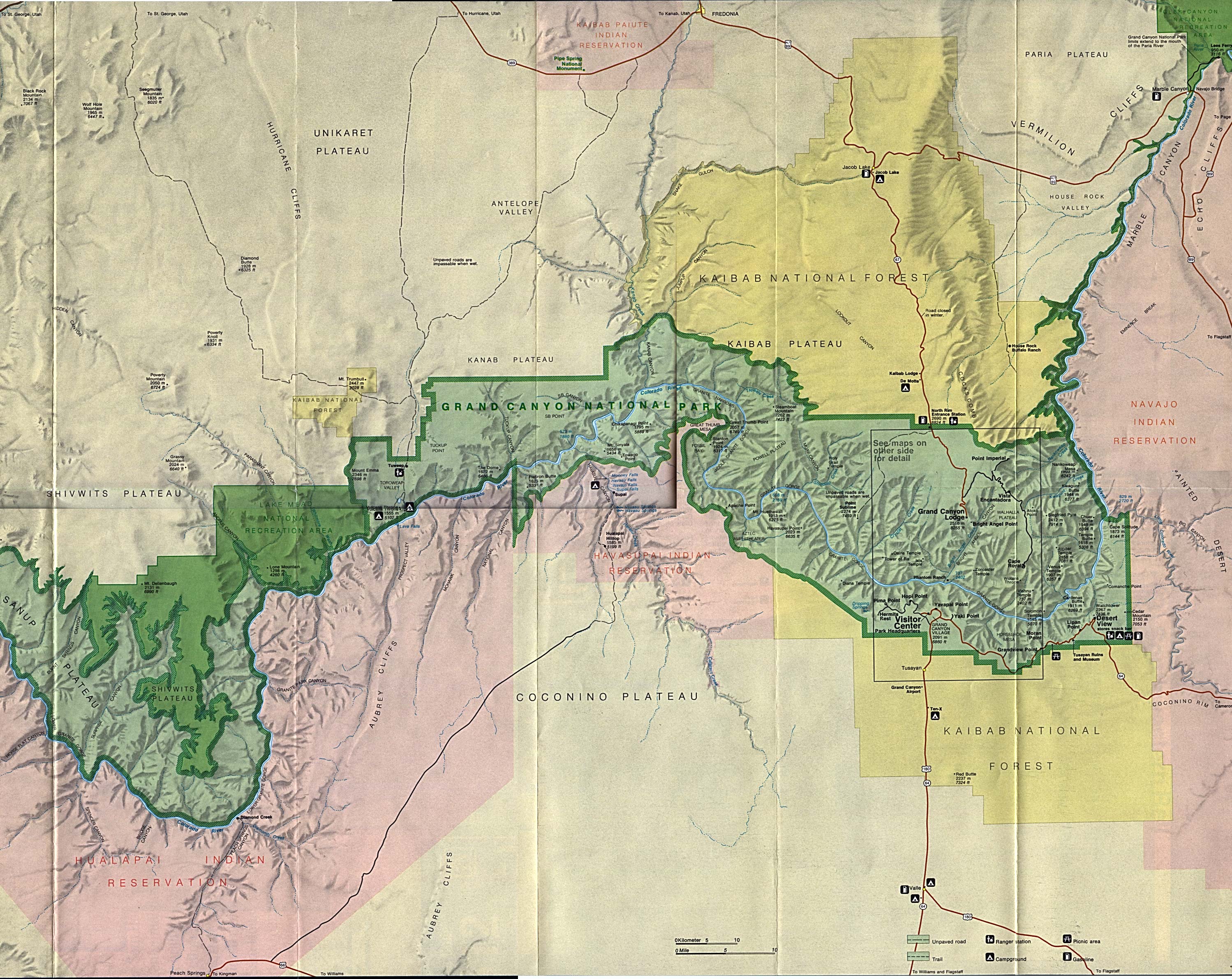
The faithful weather radio was now predicting sunny weather for the next day, but with increasing winds and perhaps another significant snowfall the following night. Sure enough, the morning dawned clear. By 8 AM, we were back into Arizona, looking out over massive Glen Canyon Dam (LINK || Map ) and down Marble Canyon from the Visitor Center's vantage point. From there, the road south led toward our appointment with the Grand Canyon. It briefly climbed high enough to be back in winter, with expansive views across Marble Canyon to the Vermillion Cliffs.
At the junction with highway 160, we took a short sidetrack to the east toward Tuba City to visit a dinosaur track site (Map) that was a fuzzy memory from my childhood. I was about to turn around, thinking the site was no longer signed, when a small hand painted arrow pointed the way. A friendly Navajo fellow led us around the site, showing off far more features than I remembered from the site for a small gratuity. Tracks of all sizes (1, 2) were everywhere. He even pointed out a fossil claw and several bones.
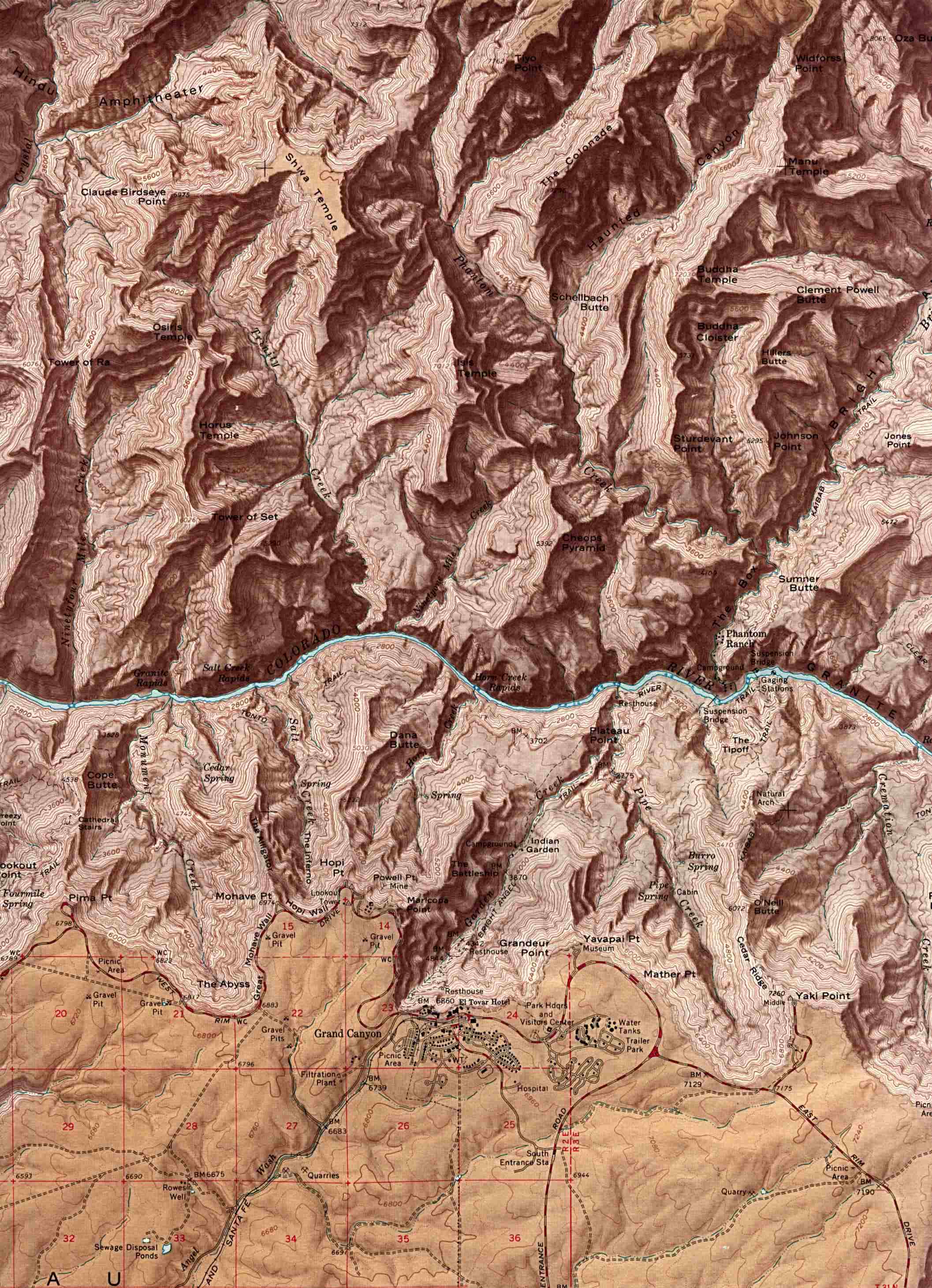
The sky grew cloudier on the way toward Grand Canyon. The San Francisco Peaks, whose snow capped summits showed brightly earlier in the day, had disappeared as we drew near. The wind was becoming bothersome at the Little Colorado River Gorge wayside. At Desert View, home of the Watchtower (Inside), which was the first viewpoint over the Grand Canyon (LINK || Park Map - 1Mb || Shaded Relief - 506K), a few patches of sunshine still painted the canyon, but it looked ominous to the west. I made a major mistake by not stopping at Navajo and Lipan Points, because shortly after we passed them, the snow started to fall. By the time we pulled into Grandview Point to make lunch, the canyon had for the most part disappeared. There was already snow and ice on the ground, left over from the previous storm. I managed to slip and fall on my !#!! as I walked down the beginning of the Grandview Trail.
After lunch, we continued on to Grand Canyon Village, and luckily found a parking spot right next the Bright Angel Lodge (LINK). Light snow kept falling while the weather radio continued to insist the snow would not start until evening. We walked along the rim to the start of the Bright Angel Trail, where we saw a group laden with backpacks arrive back at the rim. They looked to be quite soaked, and I could relate to their experience.
The first time I hiked across the Grand Canyon, I was about 12 years old and just starting in Boy Scouts. On that trip, we arrived at the South Rim at the start of the Memorial Day weekend. There was 6 inches of snow and it was still falling. Most of those boys had never seen snow before. That night we tried to make the picnic tables at Phantom Ranch our shelters from the rain as we were instructed that we would not need tents!
Back to the present....as we pulled away from the Lodge, the snow suddenly increased greatly in intensity. Heading south, the road was staying mostly bare and wet. 30 miles south of the canyon was a decision point. We were heading for Flagstaff. A more direct 45 mile route would pass close to the San Francisco Peaks at a considerably higher elevation, while a 60 mile route would stay lower and reach the Interstate 40 in just under 30 miles. The snow had let up some, and I decided the shorter route would be faster, and therefore give us the best chance to get ahead of the storm.
All was well for the first 25 miles, but that last 20 got interesting. The snow really started to fall hard. The road became snow packed, but didn't seem too bad. I remembered several pretty open parklands (Map) were on the route. They turned out to be nightmares to cross. Out of the trees, the wind driven snow created complete whiteout conditions, and the drifts were quickly becoming serious obstacles. Once we crossed the pass, and Flagstaff was only 12 miles away, I thought we had it made. I was wrong.
On a fairly straight stretch of road, the car in front of me suddenly spun out of control. It was a small car. A Dodge Neon, I think. It went sideways, over-corrected, and did a 180 so that it was still crosswise across both lanes. All this happened minutes after Linda kindly asked me not to follow it quite so close. I can't imagine how helpless that car's occupants must have felt seeing that motorhome bearing down on them! The motorhome handled great in the snow! It stopped well short of them, and never even felt like it was going to slide. An oncoming car in the other lane managed to stop too, so no harm was done, but I'm sure it scared the hell out of everyone involved.
Flagstaff was a blur as we sped on through, heading for Interstate 17, which goes directly south to lower and warmer climates. The snow stopped falling only a few miles south of town, but there was still better than a foot on the ground, left over from the previous storm. We took a well needed break at a rest area once the roads became ice free. Soon, we were dropping off from the high country into the Verde River valley. Below 4000 feet, there finally was no signs of snow in the sky or on the ground.
We pulled into Clear Creek Campground (Map), at 3100 feet, in the bottom of the Verde valley,just after 5 PM. Phoenix was only some 85 miles further south, but was over another 5000 foot pass. The weather radio continued to predict a major snow storm overnight, with the snow level as low as 3500 feet, which was low for Arizona, even if it had been January.
The Forest Service campground was very nice, with widely spaced sites in a grassy grove of Sycamore trees. It was the first place we stayed in on the trip that had full size fire pits with grills. We still had lots of fire wood, and since it was our last night of camping, I built a huge fire and cooked t-bones on the grill.
I heard the precipitation pattering on the roof sometime during the night. I assumed it was rain, but in the morning, everything was white. I would guess that the area around Camp Verde sees snow free winters about as frequently as not. Despite the snow, the Easter Bunny managed to pay a visit to the motorhome. We spent most of the morning packing for the trip home, and then visited nearby Montezuma's Castle National Monument, a well preserved cliff dwelling.
Lunching at Dead Horse Ranch State Park (LINK) along the Verde River, the snow continued to come in squalls, but was no longer accumulating on the valley floor. The weather forced us to abandon a visit to Jerome (LINK), a one time ghost town located well up the side of Mingus Mountain. We returned to the freeway and continued south toward Phoenix.
There was plenty of new snow at the pass, but the freeway was bare all the way over the mountains. Soon we were back in the land of Saguaros but the sky to the south looked very black. The next thing we knew, it was snowing hard again, and we were only 20 miles north of Phoenix, and probably only 2000 feet above sea level. Some cactuses were in bloom as the snow fell. We arrived in the city just after 2 PM, and it was 42 degrees and raining the Valley of the Sun.
We cruised around town for a couple of hours, checking out my old neighborhood, and visiting my old hiking grounds in Squaw Peak Park. (Map). The rain ended as blue skies moved in from the west. Due to the Easter holiday, the restaurant I had planned to dine at was closed, and we ended up having some fast food at a Mexican place. We finished cleaning up the motorhome in the parking lot, and turned it in sometime around 6 PM. We spent our last night in a nice hotel. It had a huge outdoor heated pool, which we had to ourselves in the cold evening air. Palm trees towered above the pool, and the landscaping was full of flowers in bloom. It was a fitting place to end our visit to Arizona.
We did have a great trip out west. The weather was frequently poor, but that was by Arizona standards. It was pretty good (with a couple glaring exceptions) by Virginia standards. Those first five days of April were the coldest start to the month on record for the state. Flagstaff had 33 inches of snow over that time, and has had several more snowfalls after we left. Phoenix dropped to 35 degrees on the morning we got back into town. I remember several winters in the 1970s while I lived there that 35 would have been to coldest temperature recorded for the entire winter! I'm sure that a 42 degree mid-afternoon temperature in April was completely unprecedented. Despite these facts, other than missing good views of the Grand Canyon, we had little to complain about. Our trip was a blast!
Web Counter
Source
Shivers Family Home
Page
Comments
Last Modified: March 29, 2001